


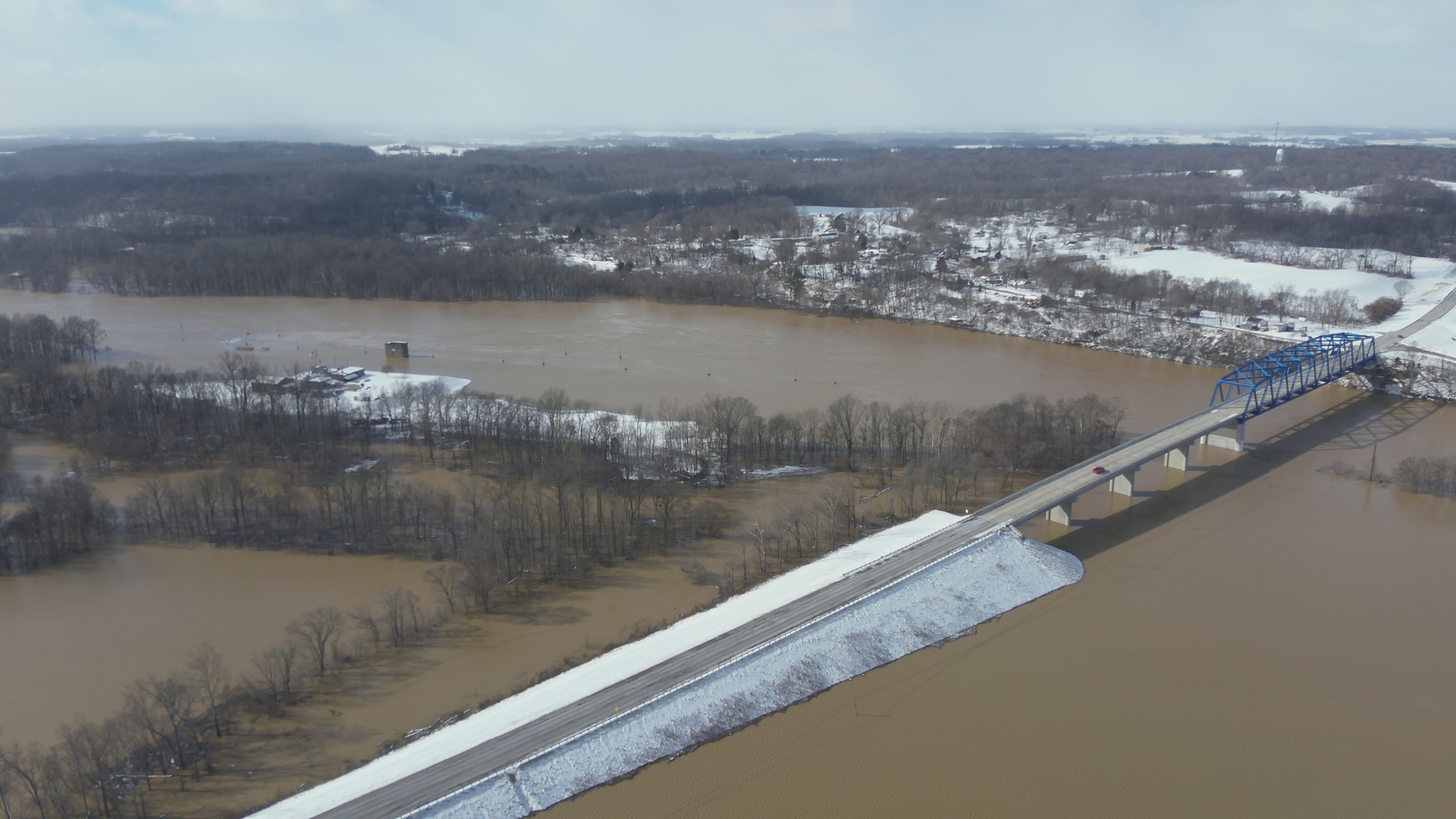
Frequent downpours and winter storms have brought both rivers in Henderson County out of their banks.
As the Ohio and Green rivers continue to rise, so does the level of preparation by emergency responders.
“We have a flooding plan we use whenever the rivers flood,” said Emergency Management Director Kenny Garrett. “That can happen every year of course. So, we have some triggers in the plan which say when river gets to this point, we do this.
“The plan is based on a pre-determined flood level. We know from history that the 1997 flood got this high and in 2011 the rivers got this high. We have all those numbers. When the rivers are forecasted to be a certain height that we know is a flood stage, we say, ‘What do we do at this height?’

According to the National Water Prediction Service, the Ohio River at Evansville hits flood stage at 42 feet. That is considered by the NWPS to be minor flooding, the website said. Moderate flooding, according to the site, occurs at 48 feet.
Garrett said the Ohio River flooding is concerning, but not yet at a critical stage.
“The Ohio River is set to crest at 44 feet on Feb. 23 which is just below our trigger for bad things to happen. We are still in prep mode, still watching …”
As for the Green River, it’s also expected to crest Feb. 23, but at 35 feet. The two rivers feed off each other, Garrett said.
“There aren’t many miles between the Spottsville boat ramp and the Spottsville dam to the mouth of the Green River where it meets the Ohio,” he said. “So, if the Ohio River comes up faster than the Green, it’s going to backflow into the Green and push that water back. When one river floods, the other one floods.”
“The big concern for me was based on the seven inches of rain expected recently. It missed us, but didn’t miss us. It went south of us and went right across the Green River basin,” he said. “Not everybody knows that the Green River is one of the few rivers in the world which flows south to north. The basin flows into the Green River and winds up in Henderson where the mouth of the Green and Ohio River come together. I was concerned with what the Green River was going to do with all that water.
“However, the Green River is supposed to crest at 35 feet. That’s not bad,” he said. “It’s not 39 feet like it was in 2018. It’s flooded, but it’s not over the main roadways. It’s over some, and we know which ones. We have cones up to keep people from driving through it, but they still do.”
Thanks to information set by flooding precedents, Garrett said emergency responders start preparing.
“Agencies double check equipment—making sure it’s in good operation, which they do frequently anyway. The rescue squad has several boats, the Henderson Police Department and Henderson Fire Department have boats.
“We have meetings, and we discuss where the epicenter is going to be; where we need to focus. We have sites pre-set if we need to put up a command post, which gives them a base of operations. There are certain high-profile vehicles that can be driven through flood waters which pickup trucks and 4-wheel drives can’t do.
“Basically, we get everyone in a room together and talk about ‘this is what I’ve got, this is what we can do.’ We talk about when’s it going to start, and how long it’s going to last. We discuss shift work, food and everything we need to make sure we have a smooth operation,” he said.
“We prep for people who couldn’t or didn’t want to get out and they are stuck. And we will have to send people in boats to get them,” Garrett said.
Bryan Coghill, chief of the Henderson City County Rescue Squad, said there are those who drive into flood waters and become stuck.
“We’ve had approximately five water rescues since Feb. 6,” Coghill said.
“Three of those occurred when vehicles drove through flooded roads and got stranded,” he said. “One was an evacuation due to the rising river, and one was a welfare check due to the rising river.”
Coghill and other emergency responders are asking people who drive into and subsequently abandon their vehicles in flood waters to call 911 and let dispatchers know the location of the cars. This small action spares rescue squad members, firefighters and law enforcement from having to mobilize and check those vehicles for stranded people.
Garrett said in a recent incident, officials assisted people whose travel trailer was surrounded by flood waters.
That scenario occurred on Feb. 19. The people were able to get the trailer out of the flood waters without help but moved it to property where the trailer was not allowed. Garrett said the trailer residents were told it had to be moved or would be impounded.
“It had to be moved, and it took us several hours” to find a new location and get it there, Garrett said, adding that the first intended area near the Spottsville bridge was already flooded, and a contingency plan was developed.
“Those are the kinds of things that pop up, and we just never know when the next 911 will come in saying with someone saying, ‘We’re stuck,’” he said.
As previously stated, part of prepping for flooding includes looking at locations likely to be affected.
“I have a matrix established of all the city, county and state roads in Henderson County. The matrix shows which road floods at what stage of the river. We use that for planning purposes,” Garrett said.
For example, when flooding is at 39 feet, then Old U.S. 60, Ohio River Road No. 1 and Ohio River Road No. 2, among others are impassable, the EMA director said.
“The east side of the county gets hit first,” he said. “Over on the west side of the county, it doesn’t start hitting until one of the rivers hits 42 feet. Then Klondike Road, Mount Vernon, Tramm Road those get flooded,” he said. “Everyone who lives out there and grew up there, know this.”
Garrett said the snow that fell Wednesday, Feb. 19 will melt and bleed into the rivers which will subsequently add to the flooding situation.
“It doesn’t take much (to cause flooding in some areas),” he said. “And we watch that closely.”

