U.S. 60-East closed by floodwaters near Reed
The National Weather Service is forecasting that the rain-swollen Ohio River will rise this week to the highest levels here since 1945—which is to say, only people in their mid-80s or older are likely to remember seeing the river higher than it soon will be.
As of Tuesday afternoon, the weather service forecast that the Ohio River will rise to 48.00 feet on the Evansville gauge by 1 a.m. Saturday, which would be the highest since 1945.
As of 5 p.m. Tuesday, the Ohio at Evansville was at 45.60 feet, meaning floodwaters could rise nearly another 2.5 feet by Saturday.
The outlook isn’t quite as bad as earlier thought. On Monday, the weather service said river levels could reach the highest level since the catastrophic Flood of 1937, which crested at 53.75 feet. But by Tuesday afternoon, it had lowered the predicted crest by six inches, meaning it might not eclipse the crest of 48.28 feet recorded in March 1945.
Still, that would be a half-foot higher than a destructive flood here in March 1997.
The river isn’t forecast to retreat from 48 feet until next Monday evening, or drop below the official Evansville flood stage of 42 feet until April 18.
Meanwhile, the Ohio at Newburgh is forecast to crest Friday at 51.00 feet, which would be the highest since 56.60 feet was observed on Jan. 31, 1937.
The Green River at Calhoun at 5 p.m. Tuesday was at 33.46 feet, which is in the major flood category for that location. It is forecast to crest at 34.70 early Tuesday evening.
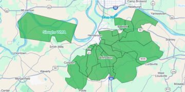
On Tuesday morning, Henderson Emergency Management announced that U.S. 60-East is closed to through traffic between the Spottsville Bridge and the Henderson-Daviess county line because of high water. Floodwater, evidently from the overflowing Green River, was observed flowing over the highway just east of Chase Road on Tuesday afternoon, and several side roads are under water as well.
Emergency Management said that only local traffic will be permitted in that area. It said the Kentucky National Guard would be assisting with traffic control, but on Tuesday, it was Kentucky Transportation Cabinet workers who were stopping traffic at the Spottsville Bridge to advise of the road closure a few miles to the east.
“Please do not try to cross flooded roads,” Emergency Management emphasized in a social media post. “It only takes 6 inches of moving water to sweep your vehicle off the roadway,” adding the mantra: “Turn around, don’t drown.”
The Kentucky Transportation Cabinet on Tuesday reported on numerous rural state-maintained roads that were under water in Henderson County and around Western Kentucky, not counting various city streets and county roads.
On Tuesday, Emergency Management had its mobile command parked at the intersection of U.S. 60-East and Peters Road, where Reed Volunteer Fire Department water rescue crew and other emergency responders were positioned as well.
***
Emergency Management said a Red Cross shelter has opened at The Gathering Place at 1817 N. Elm St. Cots with blankets and food and snacks are being provided, but those needing shelter are advised to bring:
- A pillow
- Your own nonperishable food if you have food allergies
- Medications
- Two to three changes of clothes
- A hygiene kit
- Cell phone chargers
Pets must be sheltered elsewhere, it said.
Daytime sheltering is available at the Salvation Army at 1213 Washington St. with meals available. If The Gathering Place fills up, the Salvation Army will open for overnight sheltering.
“If you need transportation to the shelters and cannot arrange it with family or friends, the team will assist with alternative arrangements,” Emergency Management said.
“We strongly recommend if you have some place to go, please make those arrangements now,” it said. “If you need to be rescued via boat by first responders, it will be a one-way trip.”
Evacuees are urged to take all important paperwork, including driver’s license and insurance documents, and to take photos of their home and property for insurance purposes.
Those evacuating are urged to turn off any propane tanks, including grills. “History has shown us they are a huge fire/explosion hazard,” it said.
***
Sandbags are available at three locations:
- U.S. 60-East at the Spainhoward Storage Facility by the Spottsville Bridge. Residents must bring their own shovels and fill their own bags.
- The Henderson County Fairgrounds on Airline Road, where this is a choice of pre-filled or empty bags. A maximum of 25 bags per residence is available while supplies last.
- Borax Drive off U.S. 60-West at the end of the roadway, where this is a choice of pre-filled or empty bags. A maximum of 25 bags per residence is available while supplies last.
***
While sure to be historic and damaging, with some homes already cut off, the current flood—triggered by last week’s rainfalls nearly 10 inches or more—won’t be as catastrophic as the Flood of 1937, the worst on record.
For one thing, the ’37 Flood crested more than 5¾ feet higher than what is expected here later this week. That flood inundated many thousands more rural acres than what will be seen this time.
Also, back then more people, with more livestock, lived in the river bottoms in communities such as Scuffletown (in eastern Henderson County) and Alzey (below Smith Mills) than today. Much of the Red Cross-led relief effort in 1937 was directed at rescuing those folks and their livestock—and, in some cases, hearing farmers’ pleas for rescuers to shoot their stranded livestock rather than let them drown.
As tragic as that event was, the city of Henderson itself fared far better than many cities—Cincinnati, Louisville, Owensboro, Evansville, Paducah and more—thanks to its settlers selecting high ground above the river at what in the late 1700s was known as Redbanks. While vast parts of other Ohio River cities were submerged in floodwaters, downtown Henderson remained dry.
That, according to local lore, inspired the phrase—“Henderson—on the Ohio, but never in it”—that helped attract new industry and pull the community from especially profound depths of the Great Depression.
In fact, that phrase appeared in The Sunday Gleaner and Journal as early as March 1925, when the Henderson Evening Journal sponsored a slogan contest that offered $10 in gold to the winner.
But the phrase was indeed revived following the ’37 Flood; a 1940 Gleaner and Journal news article reported that local citizens began using envelopes printed with the “never in it” inscription to publicize the city’s high position while memories of suffering in other cities along the river were fresh.
And new industries were successfully recruited following the ’37 Flood, with Bear Brand Hosiery quickly opening in the huge former cotton mill on Washington Street and Atlas Tack later converting a former Heinz ketchup plant off Atkinson Street into a tack and brad factory.
***
Here, according to the National Weather Service, are the previous 10-highest crests of the Ohio River at the Evansville gauge:
1. 53.75 ft 01-31-1937
2. 48.82 ft 02-19-1884
3. 48.60 ft 02-19-1883
4. 48.40 ft 04-05-1913
5. 48.28 ft 03-11-1945
6. 47.72 ft 03-16-1964
7. 47.52 ft 03-10-1997
8. 46.87 ft 03-01-2018
9. 46.78 ft 05-05-2011
10. 46.29 ft 01-01-1832
Thus, if the forecast of 48.00 feet is realized, the Flood of 2025 will rank as the sixth-highest crest here in recorded history.
Road closures
State highways:
U.S 60 between the 20-25 mile points
KY 138 at the intersection of KY 1033
KY 136 between the 0-10 mile points
KY 268 between the 1-8 mile points
KY 811 between the 3-4.5 mile points
KY 1299 between the 5-7 mile points
KY 1557 between the 2-3 mile points
KY 3522 between the 0-0.3 mile points


