


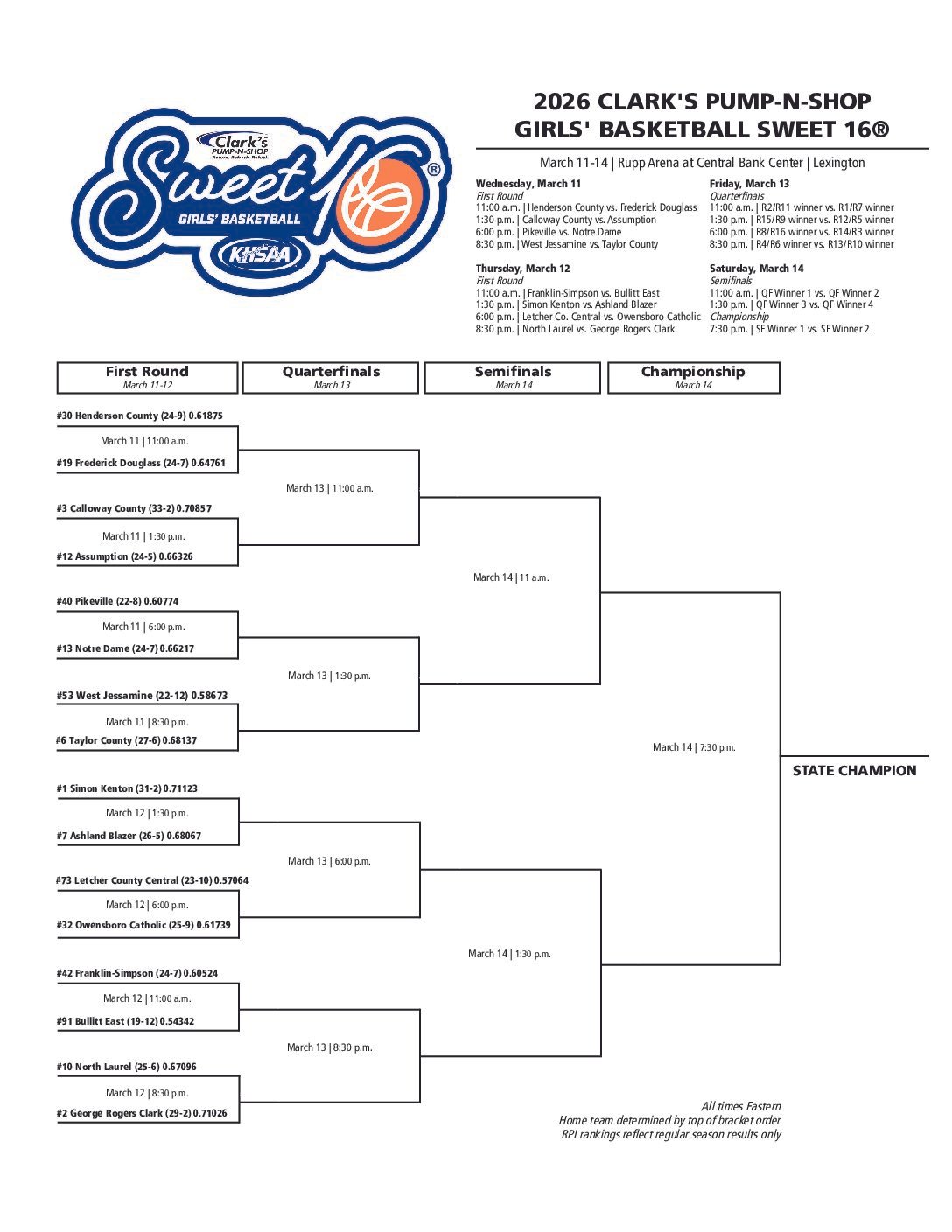


Well, the rails are washed out north of town
We gotta head for higher ground
We can’t come back ‘til the water goes down
Five feet high and risin’
– Johnny Cash
Do you know the current level of the Ohio River?
Most people nowadays probably can’t immediately rattle it off, but during the 1800s and early 1900s it was crucially important. Particularly to steamboat captains, river bottom farmers, and those who depended on river transportation to get their crops to market.
Floods pose the most obvious problem with the Ohio River, of course, but low water presented obstacles to navigation before a series of 51 dams were completed in 1929 to provide at least nine feet of water. (Dam 48, which was located about six miles downriver from Henderson, was dedicated Nov. 15, 1921.)
Knowing the river’s level was difficult before Henderson got its first fully functional river gauge in 1909. Henderson has had at least seven gauges since the 1880s but about half of them measured only the distance from the water level to the bed of the railroad bridge.
If you look at the current piers, you’ll notice markings ranging from 35 to 65 feet. The 1885 bridge had similar markings. The reason for those yardsticks, of course, was so riverboats could lower their smokestacks in times of high water.
Preparatory work for the series of dams prompted installation of Henderson’s first bona fide river gauge – but it wasn’t easily read from the shore. The Gleaner of June 19, 1906, made clear it was only temporary; a series of them were used to determine the location and probable costs of the planned dams.
“The gauge was set about 150 feet from the shore and probably 500 feet south of the Henderson bridge. The gauge is a very simple affair, consisting of a spike driven in the bed of the stream,” which anchored a cable attached to a buoy. The cable carried metal tags to measure the depth of the river.
Readings were made three times a day by William W. Shelby Jr., a sophomore at the University of Kentucky, and the son of one of the primary movers in getting Henderson a permanent river gauge three years later.
William W. Shelby Sr. was wharfmaster back then and it appears as soon as Augustus O. Stanley of Henderson was elected to Congress in 1902 Shelby began lobbying Stanley for a permanent river gauge.
It took years for the project to come to fruition; many of you probably remember the gauge that served between 1909 and 1977. One of the first public mentions of it came in the Henderson Journal of Jan. 22, 1909, which reprinted a letter from Stanley to Shelby.

“I have not forgotten your request that I use my best efforts to secure a river gauge at Henderson.” He said he had talked to the chief of the U.S. Weather Bureau, relayed the difficulty in getting timely readings from the Evansville gauge, and “explained to him in detail the absolute uselessness of the gauge which is now placed upon one of the piers of the bridge.”
Stanley said he was “very much encouraged” by the way his request had been received and said he would “not cease to press the matter.”
A follow-up story Jan. 27 noted Stanley had been placed in a position to get an appropriation for the work. That story included a letter from Willis L. Moore, the weather bureau chief, who pledged “a river station will be opened at Henderson, Ky., as soon as the necessary arrangements can be made.”
The Journal carried three stories about the river gauge in February 1909. The first on Feb. 4 reported Shelby Sr. had been hired to take readings and that an expert would be sent to help Shelby determine the best location for the gauge.
The second story, on Feb. 18, said bids were being received and that the lowest point of the gauge would be 327.4 feet above sea level, which was one foot below the low water mark of mid-October 1904, which suspended nearly all navigation.
The Gleaner of Oct. 15, 1904, began its story about the problem this way: “For the first time in the history of Ohio River boating the water is so low that every boat around Evansville has gone to the bank.”
Extreme low water struck again in October 1908, according to Maralea Arnett’s “Annals and Scandals” local history book, which noted boys were playing baseball on the dry riverbed.
The Journal of Feb. 25, 1909, reported P.J. Walz of Louisville had been in town the previous week to help Shelby locate the river gauge. Walz also noted that the low bid for construction came from the Meacham Paving Co. of Hopkinsville.
High water delayed work on the project, according to the Gleaner of July 11 and the Journal of July 20. “The work of establishing it has been hindered because of the unfavorable stage of the river,” the Gleaner reported.
Work didn’t begin until September but the Journal of Aug. 17 quoted Al Brand, the weather bureau’s man at Evansville, praising the type of gauge that was to be installed.
“When I say you are going to have one of the best gauges on the Ohio River that means something, for there are some good ones, but there will be nothing better than this…. It is my belief that we will get our lowest water late in September and then work will be started.”
The Gleaner of Sept. 28 reported workers had begun excavations to install the concrete foundation, which was two feet deep and ran 325 feet up the bank. A cofferdam extending into the river was needed so the bottom of the gauge could measure the river as low as 327.4 feet above sea level.
That was what made the local gauge better than any other Ohio River gauge at that time – including the one at Evansville.
“The river falls below the gauge of our sister city up the river,” James R. Dance wrote in his “Up and Down the Ohio River” column in the Oct. 13 Gleaner. “The gauge here is down below the lowest stage ever known in the river, and can be read in very low water, long after the Evansville gauge is useless…. In the future when the water is at a low stage Evansville will have to depend on Henderson for the reading.”
Dance’s column of the following day praised other recent improvements on the levee. “For years the levee was a disgraceful place on account of the water that ran down the rocks from the innumerable springs that dot the wharf.”
The city council had recently put in a drainage system, he wrote, “and now the levee is perfectly dry. In former years when the water was receding and left a deposit of mud the springs would keep the deposit moist and the levee would be a slimy mud puddle. Now it is different.”
The Journal of Oct. 27 reported the river gauge work was “almost completed.” The job apparently was finished shortly after that. The paper said it was the finest on the Ohio River and the only one of its kind built by the U.S. government.
That story credited three men for the gauge: Stanley, Shelby, and Dance. “These three men have never missed an opportunity to plug for the improvement and seem to be fully entitled to the credit.”
The Henderson City Council minutes of Nov. 16, 1909, noted final passage of an ordinance aimed at protecting both the river gauge and the sidewalk to the city wharfboat. It prohibited people from riding or driving over them “in any way” and fixed fines of no less than $10 and no more than $25 per offense.
That gauge was located along the south line of what would now be the Third Street boat ramp. It consisted of a steel rail embedded in concrete, in which the levels were marked to denote feet, half feet, and tenths of feet.
It was paved over the summer of 1977, according to a May 26, 1978, Gleaner Question Box, which was a feature the paper used to answer questions posed by the public. A Smith Mills resident asked why some effort had not been made to preserve it, considering its historical value and usefulness.
Larry Fulkerson, Henderson’s public works director, explained that boaters had been complaining that they couldn’t drive their vehicles over it and that it was taking up space needed for parking.
Fulkerson conceded there was a need for a gauge and said the city was exploring possible alternatives. But it was a long time coming.
According to The Gleaner of April 28, 2000, when the city was in the first phase of the latest riverfront improvement project, there had been some trouble finding the old gauge under the pavement. That couldn’t happen until the contractor – Hardaway Construction Corp. – discovered an old postcard showing the exact location and emailed a copy to the city.
That allowed engineering assistant John Stroud to uncover the base of the gauge with a few strokes of a shovel.
City officials had hoped to incorporate the old gauge into the reworked riverfront – but the old gauge would no longer be accurate because of the change in the bank’s slope. Consequently, the rail was salvaged and taken to the old city garage on outer Fifth Street.
Polished pink granite gauges currently run up the middle of both downtown boat ramps, although they’ve been badly chipped in places during removal of debris.

